This 40 acre prairie was part of a 1,700-acre homestead settled in 1836 by John Blackburn Woods. For four generations, the Woods family carefully managed the prairie while protecting it from the plow as other nearby prairies were destroyed. Mary 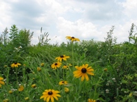 (Woods) O’Connell, the previous owner, was no longer able to care for the prairie and decided to sell it in the late 1990s. ORLT purchased Woods Prairie in 1999 to be permanently protected as a nature preserve, and initiated an aggressive restoration program, which is now nearing completion. ORLT’s long-term stewardship will consist of scouting for and controlling invasive plants, and periodic burning.
A botanical inventory was conducted over several years and published in 2005 (Thomas et al., 2005). Of the 228 plant species found at Woods Prairie, 56 species are county records that had never before been documented. Perhaps the reason that so many county records were identified is that Woods Prairie is isolated from the larger prairie region to the northwest, and that it is the last remnant prairie remaining toward the southeast as the Great Plains transition into the forested Ozarks. While few of these 228 plant species are officially listed as rare, most are quite scarce and only survive on remnant prairie preserves such as Woods Prairie.
Woods Prairie is open to the public upon request. Please contact ORLT at (573) 817-2020. Directions are below.
Directions to Woods Prairie, near Mt. Vernon, Missouri:
Latitude/Longitude: (37.091496, -93.731266)
 From east or west: On Interstate Highway 44, take the Chesapeake exit (# 49) and go east (which may seem south) toward Chesapeake on Highway 174. At about 3 miles, turn south (right) onto Highway K. Proceed 1.5 miles and turn right onto Farm Road 2125. The prairie is 3/4 mile down this road on the left.
From the south: At Aurora, MO, take Highway 39 going north through town, well past all the fast food, etc. to the edge of town. There is a stop sign and railroad tracks. At that point 39 goes left, but you want to continue straight ahead onto Highway K. The road may not be well-marked there, but essentially you never turn going through Aurora and continue straight north out of town. From there, continue north on Highway K roughly 8 miles and turn left on Farm Road 2125. This turn (FR 2125) is exactly 2.0 miles north of where Highway FF intersects on the left. The numbered farm roads will let you know when you are getting close. The prairie is 3/4 mile down FR 2125 on the left.